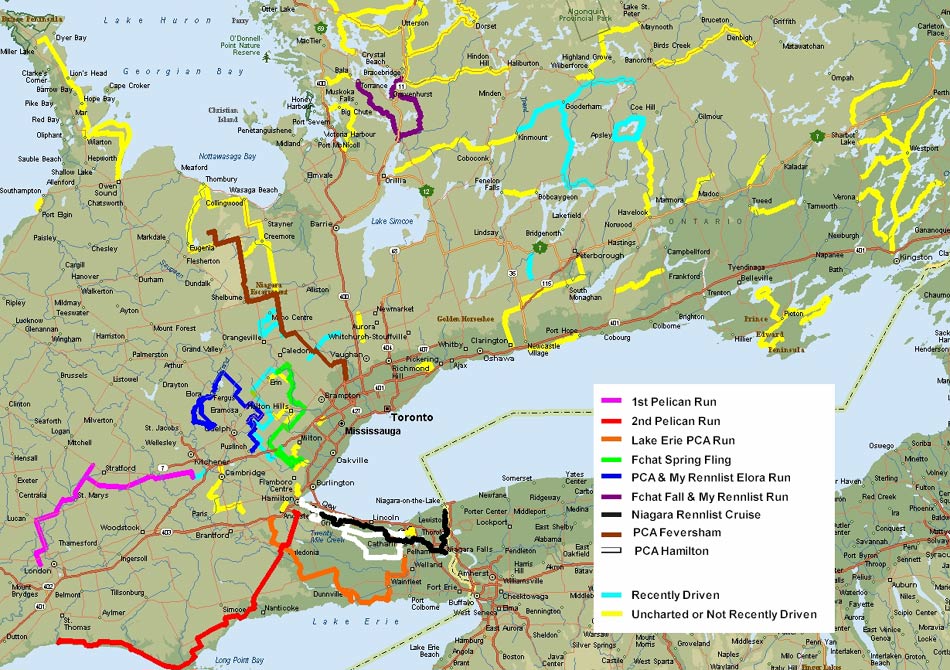
The map above represents a collection of
good driving routes in Ontario. Many I mapped from the great
website that an Ontario biker had posted. Unfortunately, I didn't
get the descriptions before the site disappeared, but I did at least map
them.
It's back at http://bikeroads.atspace.com/roads.htm
or overview map http://www.noinfo.com/ontario_bikeroads.jpg
If you have driven Ontario extensively, you will know that SW Ontario is
pretty much a write off. Straight & flat with only some river
valleys to add excitement. The 2 SW Ontario Pelican Runs on the
map were great social events but the roads were certainly not
twisties. The roads are nice Ontario farmland & the routes
chosen made them a fun drive, but your arms ain't gonna get too tired from
working the wheel.
The Niagara escarpment provides some entertainment to the Western Golden
Horseshoe Area. Although the price is that they are usually pegged
at 70 kph. The Lake Erie & Elora Runs, as well as the
Fchat Spring Fling all benefited from this geographic feature.
The Toronto to Oshawa to Lake Simcoe area is a wash due to a virtual sea
of SUVs & minivans & numbingly slow speeds - unless you
want to do late night runs on the DVP . . . As you would
expect, the majority of interesting drives are north of Lake Simcoe in
Muskoka or well east of Toronto in the Kawarthas or the lake area north
of Kingston.
The Fchat Fall route is the best twisty road that I have found in
Ontario. I added an easterly element for My Fall Rennlist Run that
was more sedate, but a good warmup & capable of higher speed running
certainly.
As you can see, there are a lot of uncharted roads that need to be
driven & I am determined to try them all.
Please Note: These are public roads & not race tracks. A
safe & moderate speed should be maintained at all times.
Depending upon the time of day, you will share the roads with cars,
tractors, school buses, cyclists, motorcycles & Mennonite
buggies. Noisy fast cars are a nuisance to many so respect the
local populace & be prudent. And always be safe!
|